
The United States Experiencing The Second Widest Spread of Severe Drought in 12 Years
 Kyriaki (Sandy) Venetis
 It’s getting hotter and hotter, and drier and drier for most parts of the world, and the United States is especially feeling it.
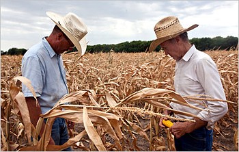 Photo by Mashid Mohadjerin from The New York Times.
The U.S. Drought Monitor has released mapping analysis for July, showing the month to have the “second largest” geographic expanse in severe to worse drought conditions, since the mapping began about 12 years ago.
Many of us, especially if we live in metropolitan areas, don’t usually think about water until there is very little of it. In these times, we remember that it’s our most important resource for drinking, cooking, bathing, washing, etc.
In agricultural communities, water takes on the added importance of sustaining livestock and crops – and this is important to everybody because they feed us.
To understand the significance of the different drought terms, the drought monitor explains that, “Moderate drought’s telltale signs are some damage to crops and pastures, with streams, reservoirs or wells getting low.”
“At the other end of the scale, exceptional drought includes widespread crop and pasture losses, as well as shortages of water in reservoirs, streams and wells, creating water emergencies,” the monitor adds.
To give an understanding of the numbers we are dealing with, the monitor said, “The July 10 map shows 37 percent of the contiguous (adjoining) 48 states in severe drought or worse.” This is the second largest expanse since Sept. 10, 2002, when the drought area was at 38 percent.
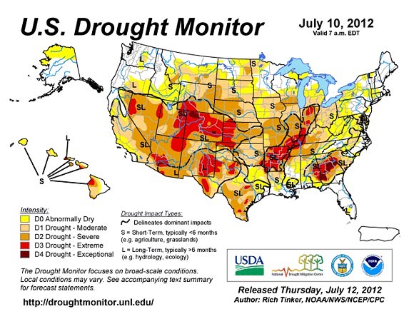
Looking beyond the most severe conditions to the overall drought conditions, it’s a worse picture with the monitor saying, “Looking only at the 48 contiguous states (on the July 10 map), 61 percent of the country’s land area was in moderate drought or worse, up from 56 percent the week before. The previous record was 55 percent on Aug. 26, 2003.”
Michael Hayes, director of the National Drought Mitigation Center at the University of Nebraska-Lincoln, expressed concern, saying that, “The recent heat and dryness is catching up with us on a national scale.”
“Now, we have a larger section of the country in these lesser categories of drought than we’ve previously experienced in the history of the drought monitor. This is similar to the 1988 drought, which was the last serious drought in the Corn Belt (traditionally, the Midwestern United States, roughly covering western Indiana, Illinois, Iowa, Missouri, eastern Nebraska, and eastern Kansas),” continued Hayes.
Brian Fuchs, a climatologist at the National Drought Mitigation Center and one of the authors of the U.S. Drought Monitor, echoed concerns saying that, “we continue to see the drought intensifying. The dryness and heat wave pattern are still locked in. The latest forecast says this isn’t changing. This could easily go into September.”
The U.S. National Oceanic and Atmospheric Administration (NOAA) had similar data, saying that, “The first six months of 2012 were drier than average for much of the contiguous U.S,” with these conditions stretching from the West, through the Central Plains, into the Ohio Valley and Mid-Atlantic.
In June, NOAA said that drought conditions had expanded and intensified in the Midwest and areas of the Midwest have seen the drought quadruple during the month, with severe drought increasing “from less than two percent to more than 15 percent of the region. “
“Extreme drought was introduced to over five percent of the Midwest in June. Farmer reports of pasture conditions and row crop conditions deteriorated as the month progressed with many areas in the southern Midwest reporting the poorest June conditions since 1988.”
To speed up the process of getting aid to disaster stricken areas across the country, including severe drought areas, the U.S. Department of Agriculture (USDA) said that it is simplifying its processes for designating disaster areas.
The new disaster relief program improvements will include:
- A 40 percent reduction in processing time for most counties affected by a disaster.
- A reduced interest rate to 2.25 percent from the prior 3.75 percent for emergency loans.
- A payment reduction to 10 percent from 25 percent for the use of Conservation Reserve Program (CRP) lands qualified for haying and grazing this year.
As of July 12, the USDA has designated about 1,000 counties in 26 states as natural disaster areas, making all qualified farm operators eligible for low interest emergency loans from the USDA’s Farm Service Agency (FSA).
The USDA is encouraging all farmers and ranchers to contact their crop insurance companies and local FSA centers to report damages to crops and livestock losses. In addition, the USDA is also reminding everyone to keep thorough records of losses.
Reader comments and input are always welcomed!
Reader Comments